


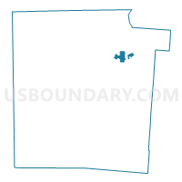
PRECINCT HARRISON-C, Montgomery County, Ohio
About
Outline

Summary
| Unique Area Identifier | 650163 |
| Name | PRECINCT HARRISON-C |
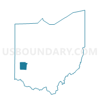
| County | Montgomery County |
| State | Ohio |
| Area (square miles) | 1.41 |
| Land Area (square miles) | 1.38 |
| Water Area (square miles) | 0.02 |
| % of Land Area | 98.23 |
| % of Water Area | 1.77 |
| Latitude of the Internal Point | 39.82276440 |
| Longtitude of the Internal Point | -84.18336300 |
Maps

Graphs
Select a template below for downloading or customizing gragh for PRECINCT HARRISON-C, Montgomery County, Ohio


Neighbors
Neighoring Voting District (by Name) Neighboring Voting District on the Map
- PRECINCT DAYTON 3-B, Montgomery County, OH
- PRECINCT DAYTON 3-D, Montgomery County, OH
- PRECINCT DAYTON 3-G, Montgomery County, OH
- PRECINCT DAYTON 3-N, Montgomery County, OH
- PRECINCT HARRISON-B, Montgomery County, OH
- PRECINCT HARRISON-N, Montgomery County, OH
- PRECINCT HARRISON-O, Montgomery County, OH
- PRECINCT HARRISON-P, Montgomery County, OH
- PRECINCT HARRISON-V, Montgomery County, OH
- PRECINCT HUBER HEIGHTS 1-E, Montgomery County, OH
- PRECINCT RIVERSIDE-K, Montgomery County, OH
- PRECINCT VANDALIA-P, Montgomery County, OH
Top 10 Neighboring County Subdivision (by Population) Neighboring County Subdivision on the Map
- Dayton city, Montgomery County, OH (141,527)
- Huber Heights city, Montgomery County, OH (37,142)
- Riverside city, Montgomery County, OH (25,201)
- Harrison township, Montgomery County, OH (22,397)
- Vandalia city, Montgomery County, OH (15,246)
Top 10 Neighboring Place (by Population) Neighboring Place on the Map
- Dayton city, OH (141,527)
- Huber Heights city, OH (38,101)
- Riverside city, OH (25,201)
- Vandalia city, OH (15,246)
Top 10 Neighboring Unified School District (by Population) Neighboring Unified School District on the Map
- Huber Heights City School District, OH (41,647)
- Vandalia-Butler City School District, OH (23,930)
- Mad River Local School District, OH (21,847)
- Northridge Local School District, OH (10,983)
Top 10 Neighboring State Legislative District Lower Chamber (by Population) Neighboring State Legislative District Lower Chamber on the Map
Top 10 Neighboring State Legislative District Upper Chamber (by Population) Neighboring State Legislative District Upper Chamber on the Map
Top 10 Neighboring 111th Congressional District (by Population) Neighboring 111th Congressional District on the Map
Top 10 Neighboring Census Tract (by Population) Neighboring Census Tract on the Map
- Census Tract 805, Montgomery County, OH (6,624)
- Census Tract 1001.01, Montgomery County, OH (6,313)
- Census Tract 903.02, Montgomery County, OH (6,296)
- Census Tract 1102.02, Montgomery County, OH (3,047)
- Census Tract 807, Montgomery County, OH (2,135)